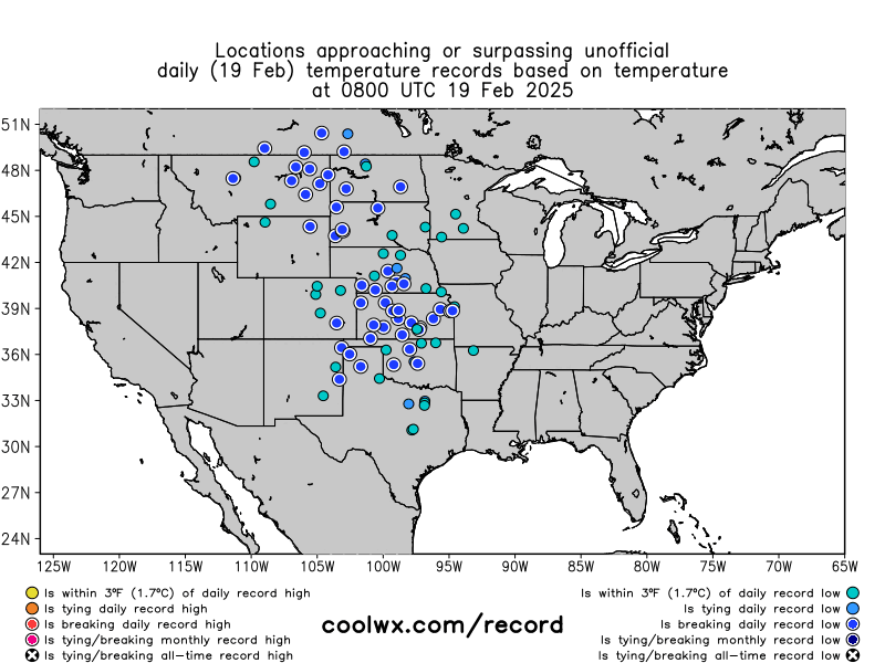
Deep Freeze Grips Central Europe; Long-Standing Records Fall Across America; One Of Antarctica’s Earliest -60Cs On Record; + Solar Superstorm
The Establishment is coping hard. Orwellian double-speak is up to eleven: “Earth is warming, so why is it so cold?”
 Unlock with Patreon
This is almost unprecedented.
Well in OUR lifetime that is but I never expected full blown cold after cold this year. But okay we can live with that by staying WARM…WHERE IS THE WARMTH DEB???
everybody tonight is the COLDEST night so wrap up, put more wood on the fire and bring your Dogs/cats in to survive.
42F here at Midnight, 18 degrees warmer than a week ago when there was nine inches of snow in my yard. It’s been warmer all this week with lows in the low 40s which is warmer than ave. Temp here last year this date was warmer than ave too. Couldn’t be happier about the nice warmer than ave weather from solar max.
KY Mikey P, you expected record snow this Winter bigger than the blizzard of 1978 and said it many times months ago like every year. Cold snap almost over, back to normal.
NASCAR in Atlanta this weekend, cooler than ave but sunny and good to go. Then on to Texas next weekend forecast 71F sunny, good to go. 😎
AZ next, March 9 forecast sunny god to go. Hammer down out of Winter 200mph next race Vegas then Florida screw all this record cold crap.
Eric Keyser writes that the temperature was warmer in the 1850s than it is now.
Have climate scientists missed how warm it was in the 1850s?
Eric Keyser;
“The monthly temperature data archived by BerkeleyEarth.org in 2013 provides some compelling insights. For example, the warmest months on record were July 1852, July 1868, and July 2006. From 1706 to 2013, the average yearly temperature shows a warming trend of 0.33°C per century, with an R² confidence level of 26%. Interestingly, the data reveals a cooling period from 1870 to 1960, followed by a more recent warming trend consistent with satellite LAND data, which also demonstrates warming since 1980.”
“It’s also worth noting that historical records show a remarkable 4.6°C increase in average annual temperature from 1805 to 1868—long before the industrial revolution. This suggests that natural temperature fluctuations over 50- to 100-year periods are an inherent part of climate variability.”
https://www.linkedin.com/posts/eric-keyser-82861111_update-ipcc-model-hadcrut5-added-to-debilt-activity-7289421284088721408-HT_V
For more details, follow this link to view my slides.
https://docs.google.com/presentation/d/1zcJd6BgIhZLgYrxwrRvu3YPPkPyCqjfZXES968jJaJY/edit?usp=sharing
Solar cycle #3 in 1778 is the strongest on the SC chart. Then #5 in 1804 is the smallest. Tambora erupted in 1815 during the peak of SC6 also a small SC and that cooled the planet down no summers for years. 1837 SC8 was third strongest on the SC chart, SC9 in 1848 was strong and also SC11 in 1870. 1860 cool down SC10 was about the same size as now SC25
https://www.swpc.noaa.gov/products/solar-cycle-progression
5pm US central time a high pressure now over E Kansas and Nebraska. A low pressure in the Atlantic off DC gusting 70mph.
Coldest air now N of the high pressure in Nebraska at -10F and Iowa at -5F. N wind going around the high into N MO it’s -4F. By 5am the high pressure center over NW MO, Iowa the coldest at -14 F. The low in the Atlantic moves N off Nova Scotia overnight pulling the cold air from Canada into the US.65F on the SE side of the low out in the warmer than ave Atlantic O.
48F here today NW USA 50 miles S of Canada ave temp. It’s warm West of the Rockies up into Canada there’s a low pressure offshore in the Pacific pushing warm air up the coast with heavy rain for days starting tomorrow. Lows on both coasts and HP center of mass. Standard Winter pattern, coldest center of mass away from the oceans.