Rare Snow Hits Southern China, Historical Low Temperature Records Tumble
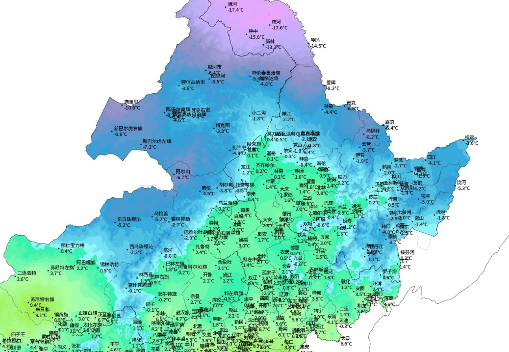
China’s Arctic Outbreak is refusing to let up, this week delivering rare snowfall as far south Guangdong province, while temperatures across the 9.6 million km² country continue to fell historical benchmarks.
Forecasters just last month had predicted a warmer winter this year due to El Niño.
On Monday however, snow was falling across Guangdong in the southeast, even blanketing areas situated near the coast.
Rare flurries were also seen in the commercial hub Shanghai on Monday.
Much of eastern China has experienced heavy snow in recent days. The 18cm (7.1 inches) that settled in Jintan, Jinagsu province broke the city’s December snow depth record. In fact, the eastern province of Jinagsu is packed with record-breakers.
Yet another fierce cold wave is forecast to enter China this week, one that is expected to deliver additional cold records across the country, including to southern provinces.
Records to accompany the myriad to have already fallen, including, but not limited to, the -48.4C in Inner Mongolia; the -31.9C in Datong (breaking the old record of -31.1C); the -31.9C in Yunzhou; the -26.8C in Yangqu (besting the old benchmark of -25.7C); Qinghe’s -22.6 (breaking -21.6C); Tianjin’s -17.9C; and Beijing’s -15.5C (the capital’s lowest December temperature since 1971).

Guangzhou officials urged precautions, especially for the old and young who may be vulnerable to “cold wave illnesses”, as the rare cold wave advanced south.
As reported yesterday, the freezing weather has also tested China’s heat supply capacity, i.e. its power grid.
The national disaster prevention body issued a directive to local authorities to prepare emergency plans, as well as snow and ice removal equipment “to ensure that the national energy supply and demand are stable and orderly.”
On Friday, President Xi Jinping called for an “all-out” emergency response to the polar outbreak, and operators have responded.
“We are in a critical period to ensure power supplies during the winter peak. Affected by the cold wave, the power load has increased significantly, with the maximum load in the company’s operating area reaching 990 million kilowatts, a record high in winter time,” State Grid Chairman Xin Bao’an said in an emergency meeting over the weekend, as reported by globaltimes.cn.
Snow is expected to continue to lash the middle and lower reaches of the Yangtze and its south, including parts of Anhui, Jiangsu and Zhejiang provinces as well as Shanghai. Local heavy snow can be expected, local forecasters added.
China’s Arctic Outbreak is refusing to letup.
A Fierce Cold Wave Sweeps Through The Arctic Stratosphere
The wave was cold, I mean really cold — so cold that rare ‘polar stratospheric clouds’ (PSCs) appeared over Sweden.
Earth’s stratosphere is incredibly dry and usually contains no clouds at all.
PSCs can only form when temperatures in the Arctic stratosphere drop to a staggeringly-low -85C (-121F), explains Dr Tony Phillips of spaceweather.com. Then, and only then, can widely-spaced water molecules begin to coalesce into tiny ice crystals. High-altitude sunlight shining through the crystals creates intense iridescent colors that can rival auroras.
NASA forecast models of the polar stratosphere show that temperatures have indeed dropped into the very low range required for colorful Type II PSCs:
During a typical Arctic winter, PSCs appear no more than a handful of times, and the first sightings usually come in January. The apparition on Sunday marks an early start, and may herald a busy (cold) season to come.
Iceland Has Cracked Open
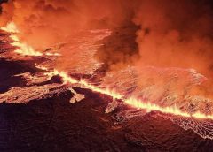
After months of teasing, Iceland has finally cracked open, unleashing torrents of lava.
“Warning: Eruption has started north of Grindavik by Hagafell,” the Met Office said on its website a little after 22:00 (GMT) on Monday.
Icelandic prime minister, Katrín Jakobsdóttir, said her thoughts were with the people of Grindavík, “now we see the earth opening up”. She added: “Our thoughts are with the local people as before, we hope for the best, but it can be clear that this is quite a blast. It is important to give emergency responders space to do their work and follow traffic instructions.”
While tourists have flocked to to see past eruptions, officials are warning this new eruption is not “tourist-friendly” and seems to be significantly larger than the Fagradalsfjall pop in 2021.
The lava was emerging from a fissure some 3km long (0.62 miles), according to local news in Iceland.
As much as 200 cubic meters (7,100 cubic feet) of lava was flowing from the crack per second, several times more than in previous eruptions in the area, Icelandic seismologist Kristin Jonsdottir told public broadcaster RUV.
Below is an update from @RUVfrettir showing the location of the eruption.
It’s currently about 1.5 miles northeast of the town of Grindavik.

“Seismic activity together with measurements from GPS devices indicate that the magma is moving to the south-west and the eruption may continue in the direction of Grindavik,” the Met Office said.
A large queue of cars formed on Reykjanesbraut after the eruption started last night:
Webcams in the region caught the first moment that molten rock breached the surface:
The current risk here is flowing lava, rather than a classic blow-off Strombolian-type eruption. The chemistry of this lava makes it very liquidy and that type of lava doesn’t usually build enough pressure to create larger explosive blasts.
As it stands, all flights in and out of Iceland are running on schedule.
Iceland’s foreign minister, Bjarne Benediktsson said on X that there are “no disruptions to flights to and from Iceland and international flight corridors remain open.”
Still, the situation is changing rapidly changing — the fissure appears to have grown since the initial estimates I gave at earlier, with reports now stating the length has exceeded 4 km.
A meeting of scientists will be held on the morning of December 19 to evaluate the development of the eruption.
Follow @Vedurstofan on X for the most up to date info.


No SO2 showing from Iceland eruption on Windy.com. No cooling effect but the volcano is emitting heat which also does not show up on Windy temp map. Nominal net results from eruption.
A low pressure area forecast over Stockholm Sweden on Thursday will bring snow to Germany and SE to Bulgaria. Eight feet new snow Norway next ten days. Five feet Austria. Eight feet E Black Sea Russia. Four feet SE Turkey.
No cyclone S of Iceland like usual pattern for years, a high pressure instead. Low over Sweden and the low pressure that was a hurricane E Coast US is still rolling up the coast in Canada. The Sweden low is a hurricane NW wind 77mph off Norway to Denmark.
https://www.windy.com/-Show—add-more-layers/overlays?pressure,2023122121,63.296,37.277,3,i:pressure,m:fiFagB1
The Iceland volcano erupted when solar flares were hitting and also the solar wind from a coronal hole. Solar wind density spiked. Cosmic ray levels went lower at the same time. Electrons stayed low, they were elevated the weekend prior.
https://solen.info/solar/images/swind.png
https://cosmicrays.oulu.fi/
https://www.solen.info/solar/images/electronfluence.png
thank you thank you thank you Cap. much appreciated.
its hard to appreciate that all that lava is liquid rocks.
Greenland temp forecast -84F next Tuesday. Low pressure area over St Petersburg, another low pressure W of UK with winds gusting 77mph, a hurricane. Another low pressure N of Norway. All the lows working together to pull cold down over Greenland. Temp now Greenland -67F. 2′ of Snow forecast S Greenland, too cold inland. Would there be ice loss from sublimation?
https://www.windy.com/-Show—add-more-layers/overlays?temp,61.843,-17.809,3,i:pressure,m:fIHae4Q
Nome Alaska Forecast -13F Friday, -21F inland a bit.
https://www.accuweather.com/en/us/nome/99762/december-weather/326709
Even colder up North in Barrow Alaska, -21F, nothing to fix there John Kerry. Bering Straits between Alaska and Russia are frozen and there’s sea ice Bering Sea down to Bethel.
https://www.windy.com/-Show—add-more-layers/overlays?waves,63.927,-165.529,6,i:pressure,m:frPavn
Hi Guys
I was out mid-morning yesterday (20/12) at the Butchers getting myself nicely stocked up for the coming festivities.
Driving back home I had to pull over as the sky…
WOW!!!
Beautiful rainbow clouds, or as I now know ‘polar stratospheric clouds’.
And I’m nowhere near Sweden but South Manchester!
Must confess, I did think Geoengineering and chemtrails were to blame (who can blame me for thinking that, right?)