Snow Piles Up In The Australian Alps, Even The Capitals
Australia has seen one of its snowiest seasons of the century, with a fresh Antarctic blast this week delivering even more.
Resorts are already reporting up to 30 cm (12 in) in the first 24 hours of the storm’s onset, with another 40–50 cm (16–20 in) forecast across the higher ranges. That will push storm totals on the upper slopes close to 1 m (3.3 ft) by Saturday, adding to season accumulations already around 3 m (10 ft) — levels not seen in years.
The Bureau of Meteorology had forecast a weak snow year back in May. Instead, Aussie ski fields are logging bumper levels.
This storm’s reach is also worth noting. Into the weekend, snow is expected within 35 km (22 mi) of five capital cities. Snow levels will fall to 600 m (1,970 ft) in Victoria, 700 m (2,300 ft) in NSW, and just 300 m (985 ft) in Tasmania. That makes a dusting possible on hills within Canberra itself, Melbourne’s outer ranges, Sydney’s Blue Mountains, Hobart’s western slopes, and even Adelaide’s Mount Lofty Ranges. Additionally, areas of the southern Flinders and Mid‑North of South Australia are likely to see snow and all.
Regional towns aren’t spared either. Snow is forecast in Orange, Lithgow, Oberon, the Monaro region, Guyra (NSW), Trentham, Omeo, and the Grampians (Victoria), plus many Tasmanian settlements—down to near sea level in some spots.

Up on the Alps, this storm is bolstering an already historic season. Resorts like Perisher, Mt Hotham, and Falls Creek hold bases of around 3 m (10 ft)—with all terrain open when storm holds allow. Blizzard conditions above 1200 m have made access tricky, but the totals are undeniable. “This season has been nothing short of spectacular,” says Perisher’s Maddi Ventura.
The front produced thundersnow over the VIC Alps and NSW Snowy Mountains:
Cold front producing thundersnow over the VIC Alps and NSW Snowy Mountains. pic.twitter.com/NWSn62SHtH
— Andrew Miskelly (@andrewmiskelly) August 29, 2025
Back in early August, southeast snowfields shattered records, posting their heaviest falls since the mid‑1980s. Parts of Queensland saw their first snow in decades, as levels dipped to around 800 m in areas of NSW and Victoria.
With 4–5 more weeks of lift operations planned, heavy snow still falling, and even low-level flakes across four states (plus the ACT), 2025 will cement itself as one of Australia’s most epic snow years of the century, despite the BOM’s relentless deception.
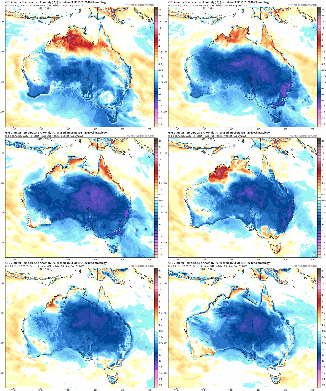
And as per latest GFS runs, August will close out very cold for practically the entire continent:

Reinforcing Cold Front To Extend U.S. Chill
Low temperatures are continuing to tumble, from Kentucky to West Virginia and into Pennsylvania.
Lexington, KY notched its third consecutive daily low record on Thursday, dipping to 48F (9C) — the coldest for the date since records began. Before that on Wednesday, the city plunged to 46F (8C) — the coldest August reading in nearly 40 years. While Tuesday tied a record dating back to 1945. Average lows for late August sit around 64F (18C).
In neighboring West Virginia, Huntington fell to 48F (9C) Thursday, breaking a 1986 mark, while Parkersburg tied its long-standing record at 45F (7C). Records in both locations stretch back almost a century.
Central Pennsylvania saw a reinforcing cold front sweep through Thursday into Friday, dragging highs well-below average, with many northern areas struggling to hit 60F (16C). A cold day followed on the heels of Thursday morning’s record-breaking chill.

Hundreds of low temperature benchmarks have fallen across the U.S. this week. Parts of the Plains and Midwest registered temperature departures of as much as 30F below average Tuesday/Wednesday, sparking frost advisories in the Upper Midwest.
And now looking ahead, another polar front is lining up out of Canada.
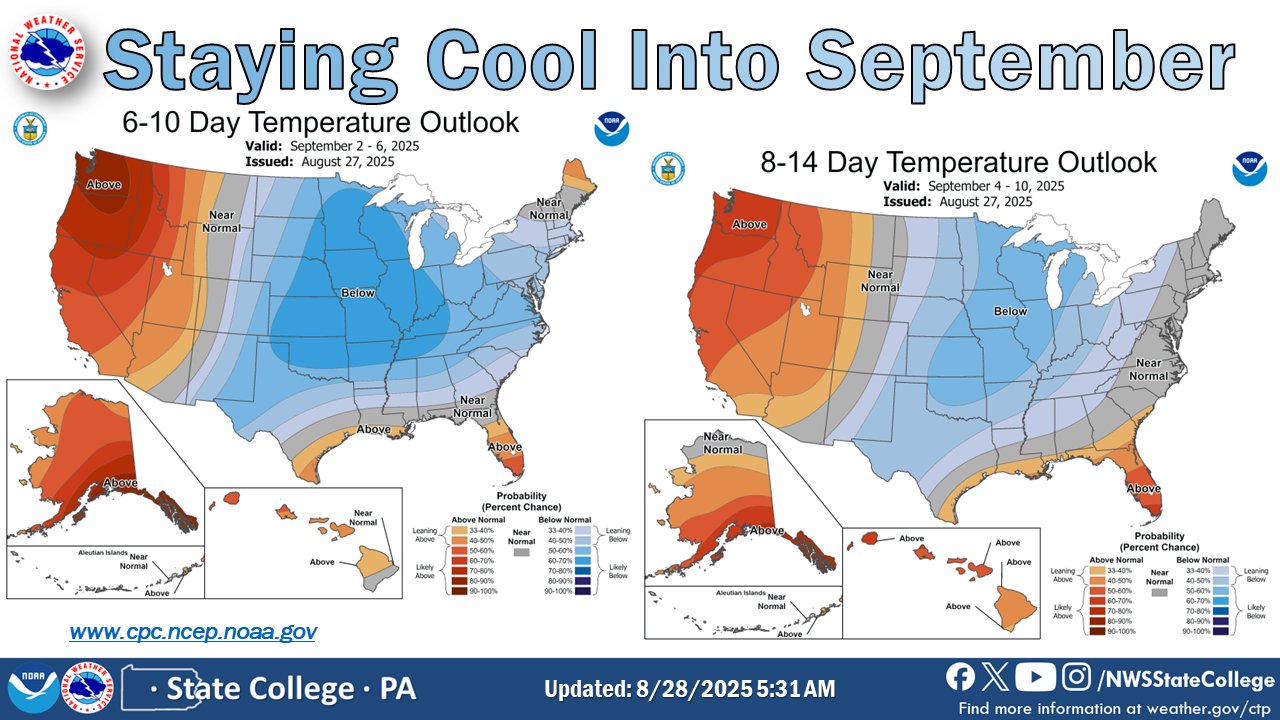
Even NOAA’s Climate Prediction Center sees it — a wide swath of anomalous cold from the Dakotas down to Texas, extending east into the Ohio Valley and Great Lakes. Mainstream have no choice but to concede: the U.S. is headed into early-season cold.
Global Wildfire Area Down 30% Since 2002
Contrary to the placard-brandishing alarmists that march Western streets, the world is not burning up. Satellite data from the Global Wildfire Information System show that the total land burned by wildfires each year has fallen by 28.5% since 2002.
Back in the early 2000s, close to half a billion hectares were burning annually. Today, that number sits near 350 million (and falling). The decline has been steady and clear across savannas, shrublands, forests, croplands, and other terrain.

While the media scrambles to frame every regional outbreak—California, Australia, the Mediterranean—as proof of “climate breakdown,” the global picture tells a very different story: wildfire activity is declining, not increasing.
The data is all there, alarmists — consume facts not spin.
Atlantic Is A Ghost Town
We’re now pushing into the heart of the Atlantic hurricane season — the period when activity normally surges. Yet the basin looks barren.
Aside from one low-probability wave off Africa, the tropics are silent:
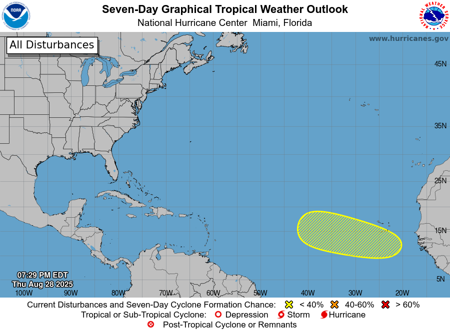
During the peak, the Caribbean, Gulf of Mexico, and western Atlantic are all void of storms. The season still has weeks to run of course, but as of late-August it is practically a ghost town out there. Fingers crossed it stays that way.
Like wildfire trends, hurricane data refuses to play along — another persistent headache for the AGW Party:

Thank you for your continued support.
Enjoy your weekend.
I’ll be back Monday, as always.
Best,
Cap




With each new quarter, the Australian BoM proves their forecasts are based on nothing more substantial than pixie dust and unicorns.
They are committed global warming warriors and are loathe to climb down off their high horse.
Frigulation-Tribulation the future if the Grand Solar minimum comes into being.
The following is my personal assessment of what the future brings void of the political issues that will ensue.
My Qualification, being observant & paying attention plus some basic laws of physics that scientist up to now have overlooked.
Challenge, Can any of the 97% of top scientist that believe in global warming explain why this won’t happen? Something that the scientific community just plainly missed.
Ice age missing link:
The thermal exchange zone is growing hypothesis!
What is the thermal exchange zone?
It is the area in the northern hemisphere where the upcoming winters snowfall is destined to melt off in the following spring and summer.
Ice doesn’t just melt. It leaches out of the atmosphere 144 BTU’s of warmth for every pound of ice that melts. As snow creeps further to the south or to the north in the Southern Hemisphere, the thermal exchange zone expands, gets deeper and remains in effect for a longer duration. It also increases the Albedo of the planet. The net effect is the lowering of global temperatures.
Excess moisture in the atmosphere is the chief cause forcing vertical atmospheric convective currents into hyper drive. Vertical currents bring cold down and warmth upward.
The earth is rapidly casting off heat.
In an atmosphere where there is 1/3 warmth and 2/3 freezing, this mixing and inverting of the atmosphere Is ominous on the surface parts of the planet.
According to the GSM experts, as the cosmic rays increase a consequence of the GSM, they will produce/condense more moisture aloft. More moisture aloft combined with a dormant sun has us heading towards ice build up & the lowering of sea levels. If at some point, and I hope it’s soon, the moisture aloft reduces, then the melt off will exceed the growth and we are heading back to an interglacial period.
GSM = excess moisture in the atmosphere =
a parallel convective current joining long wave radiation in the dissipation of heat into space.
The formation of snow in the upper atmosphere has a six fold compound cascading cooling impact. One thing happens it snows, but the impact is multiplied by six mimicking a quantum mechanics event.
1. The state change from water to ice deposits heat in the upper atmosphere. It is being deposited at the rate of 144 BTU’s per pound of water that is converted to snow, at the very minimum. This deposited heat will be dissipated into and radiated off into the background temperature of space which is estimated to be -455*f
2. Snow fall is a key event governing and controlling the cooling process. For the vertical current to provide cooling there must be a separation between the heat absorbed by the upper atmosphere and the ice that was created when the upper atmosphere surrendered part of it’s volume of cold or lack of heat. The gravity driven falling snow provides the separation from the heat that was deposited in the upper atmosphere or left behind during the snow formation and state change from liquid to solid. The snow fall also causes an updraft that draws even more heat up from the surface of the earth.
3. The snow makes a color change to the surface of the earth. The Albedo of the planet is increased. During the advancing spring, sun light will strike the surface of the snow at an obtuse angle reflecting it back into space instead of the earth absorbing that vital warmth. The greater the snow accumulations, the more sunlight is reflected back into space.
4. When the snow on the ground finally melts it absorbs 144 BTU’s per pound of snow, which robs the earth of some of the warming provided by the sun. You already lost 144 BTU’s per pound in converting moisture to ice and now your going to lose another 144 BTU’s per pound to convert the ice Back to water. 288 BTU’s at the minimum. Double dipping the conversion loses.
5. The snow melt increases the wetted surface of the earth creating even more opportunity for excess moisture in the atmosphere. Excess moisture creates the possibility of still more snow. Vicious cycle.
6. The process of water evaporation in and of itself has a cooling effect. The greater the moisture, or the wider the area the moisture covers, the greater the evaporation & the greater the cooling
7. Lastly just physical damage but that won’t cause the earth to discharge additional heat. The previous six will. The greater the volume of snow, the more acute all of these impacts become. Regenerative feedback. A cooling earth would suggest even more opportunities for additional snow formation. Until this chain is broken by the dormant sun returning to it’s normal irradiance or there is so much cold & snow that the atmosphere becomes arid, the thermal decline will continue deepening.
A snow storm’s thermal exchange rate with the upper atmosphere is roughly eight times that of a rain storm because of the state change properties of converting water to ice and ice to water. A snow storm 200 miles wide would be the thermal exchange equivalent of a 1600 mile wide rain storm.
Having said that it is important to be reminded that almost all rainstorms start out as snow. Under current conditions with excess moisture in the atmosphere, vertical currents are in play 24/7 lowering the freeze altitude.
Most people can readily see ocean currents and their thermal exchange impacts but vertical currents are completely ignored. Not a good idea when their thermal exchange capability is amped up by the state change properties of water to ice & ice to water.
Ocean currents are a closed system that merely redistribute temperature. Vertical currents are open at the upper end providing an escape portal for heat to exit the earth.
Simply put vertical currents are ushering thermal energy from the earth to the cold blackness of space at an alarming rate and
will continue doing so during the entire duration of the Grand Solar Minimum we just entered into.
Other forces reducing earth’s temperature during the GSM.
Cosmic ray driven heavier cloud layers causing increased planetary Albedo which is making the earth more reflective to incoming sunlight.
Cosmic ray driven Increased volcanic eruptions some sending volcanic aerosols up into the stratosphere where they remain for years. Another cause of sunlight reflection back into space.
Reduced solar irradiance delivered from the sun. The output of the sun will be at a lower than normal level with less flaring & less solar winds. Less solar winds translate into more cosmic rays.
Longe wave radiation. Radiation created by the heat differential between the earth and the background temperature of deep space which is an estimated -455*f just a couple of degrees above absolute zero. Even if the ambient temperature is -100* f it is still 355* hotter than the background temperature of space. No matter how hot the sun gets the longe wave radiation keeps the earth from exceeding the balance of equilibrium. The thermodynamic properties of earth favor the rapid discharge of heat. When solar output falls off the temperature of earth will spiral down.
Jet stream Meridional flow.
With the jet stream flowing more in a north to south direction, you could make a case for Meridional flow contributing to global cooling. A pump bringing warm air north into a wider radiation window.
If cold lobes of air push further into the south and warmer air mass moves unexpectedly high into northern latitudes during the winter months won’t that warm air mass be exposed to shorter days much shorter in some cases? That is allowing overnight radiation for
greatly extended nighttime hours.
The sun is only a finite provider of heat. The background temperature of space is an infinite source of cold. Dislodging warm air from the equator and moving it to the north expose it to a fridge environment with an over abundant
space earth connection to the infinite provider of cold, deep space.
What will cause the temperature to rise?
The sun returning to normal levels of irradiance.
Who would have ever guessed that the most lethal (WMD)
WEAPON OF MASS DESTRUCTION
would turn out be a simple diagram of a hockey stick in the hands of totally irresponsible & possibly corrupted scientist and governments.
More food for thought:
CO2, the greening of the earth and increased
Transpiration. The evaporation of moisture from the stems and leaves of plants. This is pure conjecture but it may be the (CO2 climate change missing link) unfortunately increased atmospheric moisture in a Grand Solar Minimum environment will only lead to additional cooling not warming.
From the reports on Electroverse it has been demonstrated that along with lake effect snow sea effect snow may become a new norm.
Mainly in the Northern Prefectures of Japan so far. Accumulated snow reported to as high 18’. Will that phenomenon extend to other regions of the earth during a Grand Solar Minimum? All that snow, ice sheets and glaciation came from somewhere.
Then there is the fuel load for fires issue. It has now been agreed upon by the experts that downed branches & dead under growth are the largest combustible fuel load for Forrest fires.
During the initial stages of the grand solar minimum, snow and ice will be extending into areas where it usually doesn’t penetrate. The foliage consisting of tropical and subtropical vegetation plus, trees with long branches unlike theIr northern cousins that have rather short stubby strong branches. The pine trees where I live have 25’ branches making them more like a small tree than a branch. More than a pickup truck load to remove. Expect trillions of downed branches and mass fragile
plant die offs. Then comes the fires 🔥 in an electrified grand solar minimum atmosphere.
Good info, for the most part.
Source?
Mystic’s Mystic
This long post tries to combine random observations from various sources that are not supported by the facts or the laws of physics.
Before you try to explain how things work and make predictions like the ones in your post you must first understand the three primary ways the sun heats the earth. Everyone knows about infrared heat that you feel on your skin and surfaces you touch, but this is the most transient heat energy from the sun. Infrared heat is stored in water vapor that rises into ever cooler regions of the atmosphere where it condenses and releases its heat, that then radiates out into the thermosphere, then to space.
Next the electromagnetic energy from the sun’s solar flares has the most dynamic effect on the earth, but is never discussed. Electromagnetic energy is captured by earth’s magnetic fields and funneled through the iron core. Iron is a resistor to electromagnetic energy and as such converts this energy into heat.
The longer strong solar cycles run back-to-back the hotter the earths core gets and this heat slowly works its way to the surface of the earth, which then begins to melt the glacier from the bottom up. The warm mountain rubble and earth underneath the glaciers allowed the melt water to seep into the ground. As the glaciers melt faster and faster the river at their base flowed less and less water, which confused and continue to confuse the clueless scientist.
This was also seen in the Eskimo larders in the late 1990s. These larders were some 20′ deep but were melted from the bottom up to within 9 feet of the surface and full of water.
But while this excess heat was working its way to the surface it was also causing the iron core soften, which effects the magnetic poles allowing them to wander and caused the magnetic fields to weaken.
As this stored heat approaches the surface of the earth it heats the mantel softening it, which allows the continental plate drift to increase in speed. (The continental drift began to increase world wide in the early to mid 1990s, some plates drift increased to as much as 200 times.) The increased plate drift along with the hotter and softer mantel allows subducted plates to go deeper into an increasingly hotter mantel, which sets the stage for extremely large large volcanic eruption to come later in this cycle.
When the increased core heat reaches the surface of the earth it warms not only the continents, but the oceans as well. The oceans act as a battery storing the heat from the core while at the same time increasing the amount of atmospheric water vapor and like the infrared heated water vapor, it rises high in the atmosphere where it condenses and releases most of the stored infrared heat into the thermosphere.
It is the thermosphere that determine whether the earth is in a warm or ice age. This is the way the thermosphere works. During a solar maximum UV and Xrays from solar flares heat the thermosphere causing it to act as a reflector, reflecting infrared heat back to the earths surface creating a heat-loop. (People from northern climates are familiar with Mylar thermal blankets. The thermosphere acts in the same way, reflecting infrared heat back to its source.) This heat-loop traps more heat under the thermosphere than it allows to escape into outer space, which causes to earth to continuously warm.
When the sun enters a solar minimum the thermosphere cools and becomes less reflective to infrared heat allowing the majority of it to escape into space. Without the infrared heat being reflected back to earth’s atmosphere, the atmosphere begins to cool and collapse. This shallow atmosphere brings the cold upper atmosphere closer to the earths surface where it comes in contact the top of thunder storms that are driven by still warm oceans and abundant atmospheric moisture. This combination creates the heavy flooding rains and violent storms the world is currently dealing with and that will continue until the oceans cool.
As the earth cools from the top down it starts getting serious for life on the crust. As the crust cools it becomes more brittle causing earthquake faults to start locking up while at the same time the mantel is still hot and more fluid, and trying to push the plates forward causing pressure to build. As the earth’s crust continues to cool and until the mantel loses its retained heat expect more frequent and stronger earthquakes.
And if this were not enough the subducted continental plates that were forced deep into the hottest part of the mantel have begun to melt creating very hot gasious magma that is liter and more fluid than the magma above it. As this liter hotter gasious magma pushes its way to the surface it finds the volcano vent plugged with cooler thicker magma, so the pressure build until an explosive eruption clears the vent. Some of these explosive eruptions could be the largest mankind has ever witnessed.
In conclusion, cosmic rays are not responsible for excess rainfall, earthquakes or volcanic eruption, but do tell us when solar minimums have occurred in the past. The increase in cosmic rays during solar minimums convert atmospheric nitrogen into carbon14, that is then absorbed by tree from that period. The wood from these trees can be later tested and dated and if the wood came from a city destroyed by an earthquake or volcanic eruption thousands of years ago, then the carbon14 levels might tell us what may have been behind this disaster.
Kids just won’t know what hurricanes are anymore! Instead, they’ll be looking for dad’s ice scraper. That includes Australia.
Is there any connection between the Cyclone Energy graph in the article and any graph from the sun?
Sunspot maximum graph does not match the Cyclone Energy graph.
Total solar irradiance (TSI) graph does not match the Cyclone Energy graph.
Does the solar polar field strength graph (PF avg) match the Cyclone Energy graph?
Solar polar fields non-filtered plot (5 year date interval).
http://wso.stanford.edu/gifs/Polar.gif
The ocean absorbs the most energy. Showing where the ocean’s energy uptake comes from shows the connection between the Earth’s climate and the influencing heat source.
An exercise in obfuscation, your forte.
Us Southern Hemisphericals are stealing more and more of your daylight hours.
Our forte.
So much for kids won’t know what darkness looks like. LOL. 😘
Especially the ones who have been blinded by the light. (and other inanities)
👍