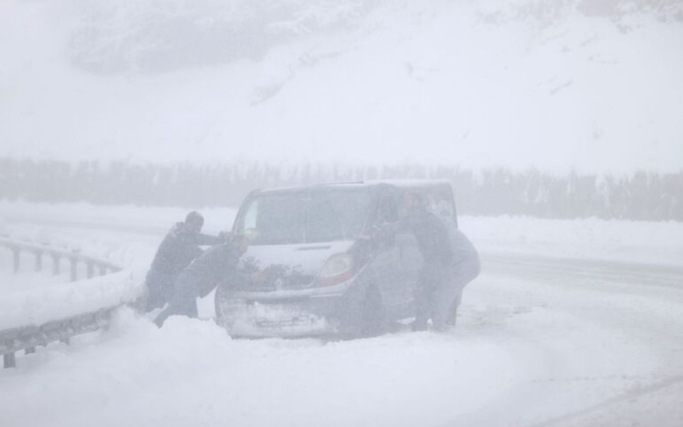
Snowstorm And Deep Freeze Sweep Bulgaria; Albania Hit; Turkey Blanketed; Greece Digs Out; + Michael Mann Is A Loser
Greece has never been colder during the month of April.
Greece has never been colder during the month of April.

Still no 40C in Europe; still no 50C globally; cows freezing to death in tropical Bolivia. Climate alarmists, where is your crisis?
The entire system is rigged.

AGW: The Unchallengeable Theory -- The breeding ground for maniacal fear and stupidity.
 Unlock with Patreon
More marvelous news about Mann.
Mann made climate change is in trouble.
Heatwave going up through the Stans, the Himalayas block the heat so it goes around them. It’s 116F in Pakistan right now, 110F in India. Way above average. The heat is going around the West end of the Himalayas and North into Russia. Updraft.
The giant heatwave does have a cold front, the cooler air from the mountains on the N side of the Med feeding into the updraft East of the Caspian. The stronger the heatwave pushes up into Russia the more cold air gets pulled into the updraft.
How much of Turkey is blanketed from snow? Looking on the snow depth map, not much. Most of Turkey not blanketed by snow. It’s 72FF in S Turkey right now, yesterday was 75F. Ave is 74F, just a normal day.
Low pressure area NE of Moscow today. Warm air coming up from Pakistan to the East, that’s the heatwave. Cold air West of the Low from the Baltic going South through E EU. Updraft, downdraft. You should see the giant heatwave going up into Russia from the Indian Ocean during the strongest electron spike on the chart. Look at the whole global temp map not just the cold fronts.
The height of the snow cover in the Moscow region has reached January values.
In the early morning hours of April 8, the snow height at VDNKh increased to 11 cm. It was this snow cover that pleased Muscovites with the New Year, when, after a festive snowy night, snowdrifts on January 1 grew from 6 to 11 cm.
To date, the range of snow heights in Moscow has increased from 8 cm in Konkovo to 18 cm in the north of the capital. At the Balchug meteorological station in the center of the capital, 10 cm.
The highest snowdrifts within a radius of 100 km from Moscow today can boast of the city of military glory Maloyaroslavets in the Kaluga region, where a snow mark of 21 cm is recorded.
https://www.hmn.ru/index.php?index=1&ts=250408110922
—
The capital region has been covered by another prolonged snowfall.
Today, 14:37
A period of snowy cold weather continues in Moscow. In the first seven days of April, 2/3 of the monthly precipitation rate fell. The height of the snow cover increased to 10-17 cm.
The capital region is located near the central part of a deep cyclone. Around noon on April 8, another prolonged snowfall began.
Wet snow is expected during the day, snow at night. The temperature will remain around 0°C. It will feel like -5 to −6°C.
https://www.gismeteo.ru/news/weather/stolichnyj-region-nakryl-ocherednoj-prodolzhitelnyj-snegopad/
—-
Cold wave and heavy rains in Turkey
The Turkish Meteorological Service warns of a severe cold wave, heavy rains and, in some provinces, wet snow.
On April 8 and the following days, rain and thunderstorms are expected in the southeastern regions of Turkey. There may be disruptions in transport operations.
In Ankara, it will rain in the coming days, the air temperature will be 6..9°C, and in the second half of the week, frosts are possible at night, 4..7°C during the day, precipitation in a mixed phase.
Turkish meteorologists report the beginning of a rainy season, which is expected to last until the end of April.
‘Ankara Spring snow forecast for April 11th’…
https://www.hmn.ru/index.php?index=1&ts=250408100505
Cold front of a giant heatwave You don’t see the giant heatwave part or what caused the heatwave. Without the heatwave there would be no cold front. Without the solar activity there would be no heatwave, the solar activity was from planetary alignments,
11cm. pfffft. 11 feet would be impressive. 11 inches still wouldn’t be news. 4 inches of snow in Moscow, BFD. Skiing is good when there’s 4 feet of new snow. 4 inches is not worth driving up to the mountains for. A flurry. BFD. 4 feet of new snow is when we drive up to the mountains to ski the knee deep untracked powder snow. We ski the avalanche chutes, steeper and deeper the better. Waist deep untracked snow is what we live for. 11cm is a joke. We go snowmobiling when there’s 12 feet of new snow. The roads finally open and it’s go time. Snowmobile/ski on Mt Baker year round,
200 inches forecast next two weeks at Glacier Bay National Park Alaska USA, the most snow forecast on the planet. 100 inches forecast N of Valdez Alaska.
https://www.windy.com/-New-snow-snowAccu?snowAccu,58.683,-136.895,10,m:fiXacmU
The Bering Sea still frozen down to Bethel where it’s 8F. -4F up in Deadhorse.
https://www.windy.com/-Waves-waves?waves,65.884,-161.644,5
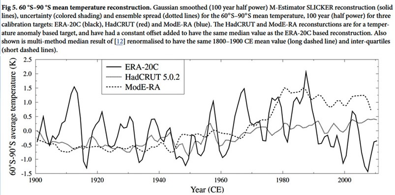
Look at the UAH GT chart, M Mann was correct, temp went up. Robert Felix said UAH GT would drop in 2015 to the bottom of the chart and stay low for decades. Wrong.
Zarkova said this SC would be weaker than the last but NASA said stronger so they won. Zarkova, looser.
Douglas Vogt is right. The Sun is increasing its heat and other radiation output as it reaches the next Gleissberg cycle maximum, when it will nova. Ben Davidson also talks about the coming micronova, as he puts it.
The snow depth map shows not too much snow in Bulgaria, Albania, Greece or Turkey. It’s warmer in Turkey than it is here inside my house. S Turkey’s temp now would be record hot here,
Athens Greece is warmer than here and they’re forecast is way nicer than here. Their forecast would be record hot here.
Minimun temperature predicted in belgian mountains (500-600m) for the last 3 days: 2-3 ºC
Temperatures observed and registered: -6 to -8 ºC
In Brussels: Predicted 4-5 ºC / Observed: -1 to -2 ºC
Models sucks! Less predictions and more real observations with real data!
Snow mas chart…Go home your drunk
Is there a problem in officialdom as the Finnish Meteorological Institute is 15 days old and NASA ice charts are 13 days old?
Zarkova nasa all wrong
Mile Mathis is correct
No black boards full of gibberish by mathamagicians
https://milesmathis.com/goody.pdf