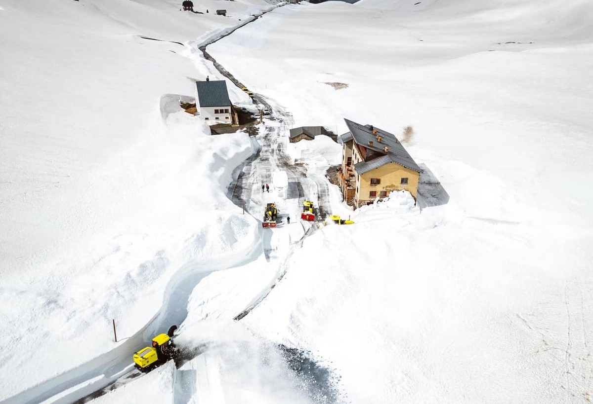
Summer Skiing In Europe After Record-Breaking Spring Snow; 1,000 Years Of Hurricane Data Ruins The Narrative; + Long Duration X-Flare
“Something special has happened in recent months [across the Alps]. “So much snow has fallen that amounts are now at record levels.”
 Unlock with Patreon
Honga Tonga atmospheric water is dumping out and the Northern Hemisphere is getting the burnt of that rain/snow. KY is at + – 32 inches already out of a normal 45 – 55 inches a year!
Although Hunga Tonga increased the amount of water vapour in the stratosphere by 10%, one of the reasons for the current spike in global temperatures, the amount of water vapour in the stratosphere is at least an order of magnitude lower than the amount in the troposphere. Therefore HT made no real difference to the total amount of water vapour in the atmosphere so will of had no effect on global precipitation amounts.
Actually they have now determined it was up to 30% more H2O and the atmosphere likes BALANCE. It will drop that out as it is doing till it equalizes.
BRUNT…not burnt,
Nice! If I had the money I would take a trip to the Alps and go skiing. (if I was 20 years younger)
Mt Hood Oregon open all Summer for skiing, catching Spring Chinook salmon in the meltwater gives you a better net result.
https://www.google.com/maps/@46.3025215,-124.0364171,3a,75y,309.17h,93.63t/data=!3m6!1e1!3m4!1s_missFRiOzRjRxKK8wsEWg!2e0!7i13312!8i6656?coh=205409&entry=ttu
https://oregoncoast.craigslist.org/boa/d/warrenton-23-foot-ranger-sailboat/7745258251.html
Lol! And if wishes were horses, we’d all ride!
Drive to Mt Rainier volcano NW US dig a snow cave in the glacier camp free all summer. Stay in there for years if you want, snow year round don’t have to go to EU. Go snowshoeing nice low impact touring. You can nail skis to a kitchen chair make a rope tow with a tote goat wheel rim ride up and down in your own snow park.
https://www.windy.com/-Menu/menu?snowcover,46.832,-121.650,11,i:pressure,m:eXgacMo
It’s a long walk to the nearest Walmart.
Closer than going to the Alps with no Walmarts. Hitchhike to NW with a backpack no travel cost. Free snow vacation. Many volcanos to choose from here all have year round snow. Want snow now we got it,
“No travel cost” -unless you hitch a ride with a serial killer. You’re thinking of the US in the 20th century, which is long gone.
Feasible though. When reaching said snowy destination one would need a big gun to scare away all the bears and mountain lions. Somehow my Irish kin got from Kansas to Washington State after the Civil War before there were cars and had a copper mine at the base of Mt Stewart. They worked in the coal mines in the mountains there in Roslyn and then got to Seattle with mules and wagons before there were cars or roads. Lots of bears and mountain lions
https://www.youtube.com/watch?v=k70sjpHwJnU
https://www.windy.com/-Snow-depth-snowcover?snowcover,47.474,-120.901,16,i:pressure,m:eYiacNE
Remember Tote Goats? One speed, granny gear.
https://www.youtube.com/watch?v=j1SmfoD938A&t=11s
Never heard of it til now –but I like it!
Tried to subscribe, but it’s one of those where you have to sign in. I don’t go for that.
Top of Mission Ridge cam, go West on the Ridge you get to Mt Stewart. Looking out over the valley into Canada where the Ice Ages have melted down the Columbia River. Town is built where the Wenatchee River comes into the Columbia, lots of gold there in the wash.
https://www.missionridge.com/mountain-report/#webcam
Love that long view from Sunspot Webcam. At home, the “long view” is about 25 ft until it hits a tree.
My Aunt Sue has 120 acres and an off grid log cabin close to the Canadian Border on that cam frame. She’s there now she’s eighty years old. She lives on an Island fulltime on the Seattle side of the Cascades in a cabin on the beach with a view of the Olympic Mountains. She was a top end Journalist in DC and worked for FEMA. Wrote a book on Pioneer Women talking to old locals and had it published. Her Dad my Grandpa was from a Homestead in Winnipeg via London via Prussia.
Drives her loco going between two places cheap Jap cars breaking down every year worried the grid’s going down got to get to the dingleberries. Too hot and cold Eastern WA can’t stay there most of the time. Bad firestorms this Summer snowpack there 58%.
Snowpack here Olympic Mountains is down to 41%. Fail.
https://nwcc-apps.sc.egov.usda.gov/imap/#version=169&elements=&networks=!MSNT&states=!&basins=!&hucs=&minElevation=&maxElevation=&elementSelectType=any&activeOnly=true&activeForecastPointsOnly=false&hucLabels=true&hucIdLabels=false&hucParameterLabels=true&stationLabels=&overlays=&hucOverlays=state&basinOpacity=75&basinNoDataOpacity=0&basemapOpacity=100&maskOpacity=100&mode=data&openSections=dataElement,parameter,date,basin,options,elements,location,networks,baseMaps,overlays,labels&controlsOpen=true&popup=&popupMulti=&popupBasin=&base=esriWsr&displayType=basin&basinType=wa_8&dataElement=WTEQ&depth=-8¶meter=PCTMED&frequency=DAILY&duration=I&customDuration=&dayPart=E&monthPart=B&forecastPubDay=1&forecastExceedance=50&useMixedPast=true&seqColor=1&divColor=7&scaleType=D&scaleMin=&scaleMax=&referencePeriodType=fixed&referenceBegin=1991&referenceEnd=2020&minimumYears=20&hucAssociations=true&relativeDate=-1&lat=48.124&lon=-120.914&zoom=6.9&autoExport=full,pdf,2,2,L,BL,Washington%20SNOTEL,49.4893,44.9175,-114.8615,-125.2705
You should write fiction.
In the Springtime the bears come out of their snow caves to eat Spring Chinook Salmon. These Nooksack Chinooks in the river at the base of Mt Baker volcano.
https://www.youtube.com/watch?v=vpFERGeULdQ
Natives thrived there based lives on the returning Salmon. Nooksack Tribe, Snohomish Tribe etc per river drainage area. Ice melted and Cyprus trees grew, our Western Red Cedar. Post ice age cultures, I found a spear head at the mouth of Mt Rainier Drainage 5,000 years old.