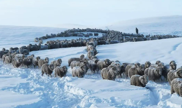
Unprecedented Snowfalls in Argentina Threaten 1 Million Livestock
Breeders in Argentine Patagonia have taken to social media to express their distress after unprecedented snowfalls buried their livestock, threatening about 1 million animals with starvation in one of the region’s coldest winters in decades.
Videos from Chubut show sheep buried in deep snow, with only their heads visible.
The Argentine Rural Confederation (CRA) has described the situation as “dramatic.”
Enrique Jamieson, president of the Federation of Agricultural Institutions Santa Cruz, highlighted the complexity of the situation, with heavy snowfalls extending across Santa Cruz, affecting about 40,000 cattle and 1 million sheep.
The most-recent snow dumps, ranging from 40 to 60 cm (1.3 to 2 ft) in depth, have rendered pastures inaccessible, endangering cattle and sheep. Efforts are underway to move livestock to areas with less snow to forage or receive supplemental feeding.
Jamieson explained that consistent, early-season snowfalls through April and May had already formed a frozen layer, complicating access to food for the animals. The recent snowfall added additional feet on top of this layer, exacerbating the problem and making it difficult for the animals to reach food.
The situation is dire, with breeders and agricultural institutions urgently seeking solutions to prevent the starvation of their livestock amidst the extreme winter conditions.
Related:
Aussie Cold
Southern and Eastern Australia is continuing to shiver through a pretty persistent and harsh cold snap, with thermometers dipping to subzero levels (C) in numerous regions.
Frost has swept the likes of Victoria, Tasmania, and South Australia, causing disruptions and posing headaches for farmers.
In Victoria, where a swatch of frost warnings have been issued, places such as Ballarat and Bendigo have posted overnight lows of -2C (28.4F) and -1C (30.2F), respectively. Melbourne too continues to shiver, hovering around 2C (35.6F) Wednesday morning.
Tasmania has also been hit, with Hobart noting -1C (30.2F). Inland areas, including Liawenee, are enduring colder lows, with -10C (14F) registered here. The severe cold has led to icy roads, prompting authorities to advise caution for motorists.
In South Australia, Adelaide recorded its coldest morning of the year at 3C (37.4F), while the state’s mid-north region saw -3C (26.6F). Farmers here are particularly affected, with the freeze posing a threat to crops and livestock.
The Antarctic air mass responsible is expected to linger and all. The Bureau of Meteorology forecasts it has at least another few days to run, with both day and night-time temperatures expected to remain well below average.
The mass of ‘blues’ is forecast to shift westwards Wednesday and Thursday:


Record Stratospheric Water Vapor
The massive impact of the Hunga Tonga-Hunga Ha’apai eruption on global temperatures and climate is striking, yet few in mainstream academia seem keen to discuss it.
When this underwater volcano erupted in January 2022, it injected a massive amount of water vapor—approximately 50 million tons—into the stratosphere, significantly altering atmospheric conditions. This increase in stratospheric moisture by about 10%-30% has contributed to a warming effect on Earth’s surface, a forcing expected to persist for years.
This chart shows the significant impact the eruption had on the stratosphere’s water vapor content. Note the initial pop in early 2022 and then the subsequent gradual latitudinal spread, particularly through 2023.

Typically, large volcanic eruptions cool the planet by releasing sulfur dioxide and ash, which block sunlight. However, the Hunga Tonga eruption was unique because it released more water vapor than sulfur dioxide.
Water vapor is a potent greenhouse gas, the most potent, leading to a warming effect rather than cooling. This anomaly explains the unexpected rise in global temperatures observed from 2023 into 2024, partly attributed to this event.
The delay between the eruption and its warming impact is due to the time it takes for the injected water vapor to mix and distribute within the stratosphere. Unlike heavier volcanic aerosols, water vapor is less affected by gravity and remains suspended longer, enhancing its warming effect. Increased stratospheric water vapor increases global temperatures, this is not contended, but it has been suspiciously sidestepped since Jan 15, 2022.
The dissipation of this water vapor will eventually occur through various atmospheric processes, including photochemical reactions and gradual settling back into the lower atmosphere. The precise timeline for dissipation is uncertain, but models suggest that the elevated stratospheric moisture levels will likely persist for several years before returning to pre-eruption levels.
As this happens, the temporary warming influence will wane, and any cooling trends or natural climate variability may become more prominent again.
The Hunga Tonga eruption has had a significant short-term impact on global temperatures via the injection of an unprecedented volume of water vapor into the stratosphere. This event has temporarily amplified the warming effect, proving again that natural events rule supreme.
Global Temperatures Took Another Step Down In June
The V6 global average lower tropospheric temperature (LT) anomaly for June, 2024 has come in at 0.80C, down 0.10C from May and down 0.25C from the April peak:

The impacts of Solar Max, El Niño and Hunga-Tonga were only ever temporary, and this ‘warming trifecta’ could now be on the verge of waning, at least in part; with Solar Maximum and the watery atmospheric aftermath of Hunga-Tonga still going strong, I would argue that the temperature dips observed in May and now June were caused solely by the weakening El Niño.
A starker temperature drop is all-but guaranteed in the months and years ahead, as the remaining two forcings eventually wane, a drop that will return us to baseline (at least), back to where we started before the trifecta took hold proper in early-2023.

Climate is cyclic, never linear, on all timescales, and driven by natural mechanisms.
CO2 Fantasticals
For fun (yes fun), I asked AI to interpret this chart for me:

This was the response I received:
The chart shows the relationship between strong/violent tornadoes (EF2+) and CO2 levels from 1950 to 2023, as well as global annual hurricane activity and CO2 levels from 1980 to 2023.
Top Panel: The number of strong/violent tornadoes (brown bars) does not show a significant increase despite the steady rise in CO2 levels (green line). Bottom Panel: Global hurricane activity (black line) fluctuates with no clear upward trend, even as CO2 levels (green line) increase linearly.
This suggests that other factors beyond CO2 levels are influencing these extreme weather events. The data challenges simplistic narratives that directly link CO2 emissions to increased severe weather incidents, highlighting the complexity of climate and weather systems.
Thanks AI.

Instead of being assholes and taxing ranchers for every head of cattle. Officials should find a way to assist in housing, feeding and maybe relocating cattle. A good old cattle drive might do some good.
They want us eating bugs.
https://youtube.com/shorts/onvJKueWPqU?si=9DzJicA1ESM-xBRr
By George, I think he’s got it!
Water vapour is the most important GHG as you say. However, it is more complicated. Most of it will be there as ice so it could also cool the earth.
Dynamic cooling, heavy rain, snow & ice help cool the atmosphere from the top down. The influence of cosmic rays increases all. These processes seem to be overlooked by climate scientists whom offer up a half of a loaf picture of things affecting the earths temperature. I agree with you.
Could it be that Hunga Tonga was purposely set off with a nuke to extend the global warming scare?
🥸
You are completely wrong!
Water vapor raises the Earth’s temperature by 33 degrees Celsius.
(0 degrees Fahrenheit to 59 degrees Fahrenheit).
Source:
In fact, most of the natural greenhouse effect is due to the concentration of water vapor in the atmosphere (10–50,000 ppm), which causes the average temperature on the Earth to be 15 °C (59 °F) instead of −18 ° C (0°F).
https://www.ncbi.nlm.nih.gov/pmc/articles/PMC10360203/
Wonderful to hear that there is no relation whatsoever between hurricanes for example and co2 levels. Just watching tv Dutch about climate change. We, mankind are responsible for climate change and we the politicians don’t want to hear anything else. So I don’t give a fuck what these idiots are talking about I don’t care but they use also my taxmoney and I can’t do anything that which makes me angry. Reading Morano’s book and laughing my ass off what an idiots those so called scientist’s frauds.
Electrons at Alert level:
https://www.zerohedge.com/technology/seattle-thieves-targeting-ev-charging-stations-has-reached-epidemic-proportions
https://www.solen.info/solar/images/electronfluence.png
Take 2, Electrons at Alert level:
https://firebasestorage.googleapis.com/v0/b/carrington-9.appspot.com/o/spaceWeatherNews%2Fgoes_electron.png?alt=media
UAH GT went up in ’16 and ’20 before Tonga during solar miminum, no solar flares.
It went up again to new record when solar activity picked up. Maybe because out mag shield is toast and let’s in more solar radiation?
Hurricanes/typhoons are from solar activity, record hurricane now in Jamaca from a solar flare. Katrina was from a solar flare you could do case studies and show the world to prove they’re not from carbon. Katrina was from a solar storm three years after solar max when they thought the cycle was over. You can see the little bump on the solar cycle spot count chart Sept 2005. 43 solar flares in 23 days, one of the flares was an X 17!
https://firebasestorage.googleapis.com/v0/b/carrington-9.appspot.com/o/spaceWeatherNews%2Fgoes_electron.png?alt=media
https://en.wikipedia.org/wiki/2005_Atlantic_hurricane_season
Recent Hurricane Ian in Florida was from solar flares, from planetary alignments. Not like anybody is going to take them to court with evidence or a surge of reality and sanity is going to break out.
S America snow from volcanos from solar flares. Pmi2.5 map loaded up for years from volcanos from solar flares. It was blank before the cycle started. Until the map clears there will be snow falling from all the volcanic particulates at altitude. It keeps getting refilled from more volcanos from solar flares. Every snowflake has a nucleus. https://en.wikipedia.org/wiki/Snowflake
https://www.windy.com/-PM2-5-pm2p5?cams,pm2p5,-2.435,-76.440,3,i:pressure,m:cRrad44
I think the big planetary alignment in December could get volcanos erupting from solar flares and it could snow all winter power out roads closed. Not from no flares. Record hot here next five days from solar flares. Record hurricane right now from a small solar flare.
I used to wait for the big thunderheads to roll in off the Pacific then get up to the top of the mountain where they were going then the cloud goes by and the sun comes out with all new foot of snow to shred. 50 years ago no weather sats no radar no cell phones. Thunder snow hanging on to trees in the wind blowin 100 mph ski the drifts and the chutes hike in for hours to get the line. Steeper and deeper the better don’t loose a ski pain in the butt on a cliff. Bring on the snow waiting for more snow please send some snow can we get some snow here already I want more I was hooked bad. Tuck Whistler/Blackcomb all day over a mile vert both areas. I hate summer I like 22F and snowing sideways 50mph.
https://www.whistlerblackcomb.com/-/aemasset/sitecore/whistler-blackcomb/maps/20231020_WB_Winter_DigitalTrailMap_001.pdf
Better stock up on TP… assuming you have enough food for a snowy winter.
City folks bought the lot across the street for weekend motorhome camping in the woods all under 150 feet tall trees he gets up and lights a campfire. It’s 70 degrees are you cold???? Bought came unglued. Guys next to them same thing spent $150k on the camping lot put in 150k motorhomes so they can build a campfire and stare at my house. Right across the street. Same behind me four motor homes on Memorial Day weekend out there getting drunk and loud forty feet from my bed. Long record hot weekend going to have to duct tape my head so it doesn’t explode.
They tell me the lake (Lake of the Ozarks) will be packed for the holiday weekend. I did my shopping today, going to stay locked up at home all weekend in the AC. I hate crowds!
When I was in my 20’s I came in contact with arguably the most intelligent person I would ever encounter. Not a personal encounter. I read his book, Zen and the Art of Motorcycle Maintenance. Robert Persig, IQ 170. I’ve probably only thought of him a couple of times in the intervening years, but today I decided to look on the Internet to see what became of him.
He’s dead now, but a speech he gave in 1974 has been posted on YouTube by his son, Ted. Very interesting. I’m going to get a copy of ZAMM and re-read it, see what it has to say to me today.
Here’s the link to his speech.
https://youtu.be/ENeYNqwK_8g?si=HhOWeLMjoJstyNsV
I read that book back then. In ’75 I joined the US Navy so I could go to college and learn more went double time for three years. Meteorology in the USN then college. Geology and Oceanography. All before Pacman was invented before they came out with all these stupid BS catch phrases that annoy me now it’s all stupid BS catch phrases that annoy me.
5am just talked to idiot across the street said he needs some firewood later from me cause they’re almost out from wasting it getting drunk. They’ll all be back later to drink all weekend. He wants to have a big campfire now???? Record heat here 100F no snowpack. NO NO FIRES NO FIREWORKS GO HOME RICH IDIOt DRUNK POS.
Dirk-
You’re amazing! I wonder if kissing you would make you real, Pinocchio? Whaddya think?
I have to hand it to you, Dirk. You seem more real all the time, even though I know you cannot possibly be.
I’m the only real one, the rest of you are simply part of the matrix I’m stuck in. The only reason I know I’m real is because I think, and Descartes told me that makes me real. I wish he would have told how to be sure whether others are real or not, or maybe I don’t.
Let me kiss you and find out 😁🤪🤣🇺🇸
Kidding Hon. Married 38 yrs happily and hope you are to Dear.
If I thought that would work, I’d kiss every frog I could find! 🐸
(And no, that’s not a slur against Frenchmen, I’d kiss 💋 every Frenchman I could find, too!)
As far as being married goes, I’m actually not sure. But I am sure I’m not going to explain that, lol!☺️
I have a strange life.
If you have the money & ability to move into a rural county do so now. The Democrats will go full Fascist now and riots & anarchy will become the niwm.
Saw that coming 20 years ago. I’m so sick of living in the woods I’m almost tempted to go back to the city. Almost.
re Australian cold – it is related to a stalled high pressure system over the south of the continent which is bringing down the cold air from the jet stream/antarctic. Apparently this high pressure system is close to or at max air pressure ever recorded for Australia.
As a result the sea level is expected to be 30 centimetres below normal while the high persists. (Compare with a supposed 1 millimetre sea level rise over x years via ice melt due to climate crisis).