UK’s Year Without A Spring
2023 has been cold and wet in the UK, with spring still refusing to sprung midway through May.
Even mainstream meteorologists are struggling to explain why winter’s gloomy conditions are still dragging on, themselves shocked by the “all the sharp frosts we’ve had this spring.”
BBC meteorologist, Tomasz Schafernaker said people are stopping him in the street, “asking when spring will finally arrive. And what have we done to deserve such cold, gloomy weather dragging on so long?”
According to Schafernaker, the answer lies in the history books, specifically the weather of the 1970s and 1980s.
“Every so often we will get a reversion to past weather habits, and that’s what we’re experiencing this year … However, thanks largely to climate change, temperatures have been creeping up — snow has become less frequent and spring has occasionally brought very warm weather, too. And we have grown used to it.”
First off, snow hasn’t become less frequent — the data show that clear as a bell:

Secondly, global temperature trends can change, Mother Nature graciously permit this — global warming is not a fixed scenario. To that point, and contrary to establishment proclamations, Earth has actually cooled since 2016 — both the satellite and land-based data reveal this.
“Last December saw below average temperatures of 1.3C for the UK as a whole,” writes Schafernaker. “It plunged as low as -17C (1.4F) in parts of Scotland.”
The cold continued through January, with Jan 23–for example–delivering Heathrow Airport its lowest temperature since 1987 (solar minimum of cycle 21). Schafernaker missed much of January’s freeze, opting for 3-weeks in Bali instead (no comment), but on his return to London later in the month, Schafernaker writes of his amazement at finding “everything frozen solid.”
February extended the anomalous chill, and March only added insult to injury: “Not only did we have a lot of snow –the Peak District was cut off– but the rain was relentless. We longed for April to turn the tide, but it was actually very mundane,” with the month overall, as with the four preceding it, finishing below the multidecadal average.
“This May has barely scraped 20C (68F),” continues Schafernaker, “meaning we’ve endured nearly half a year without any sustained period of warmth” — a reality the AGW Party doesn’t have an answer to.
Two-day summer heatwaves are easily explained, of course: “global warming is making mid to high 30s (C) and low rainfall commonplace” — a boilerplate answer every double-thinking mooncalf seems to be content with; however, periods of record-breaking cold, on the other hand, are proving a major headache for the establishment–not least because they’re increasing.
Schafernaker calls the situation “complicated” — and effectively leaves it there…
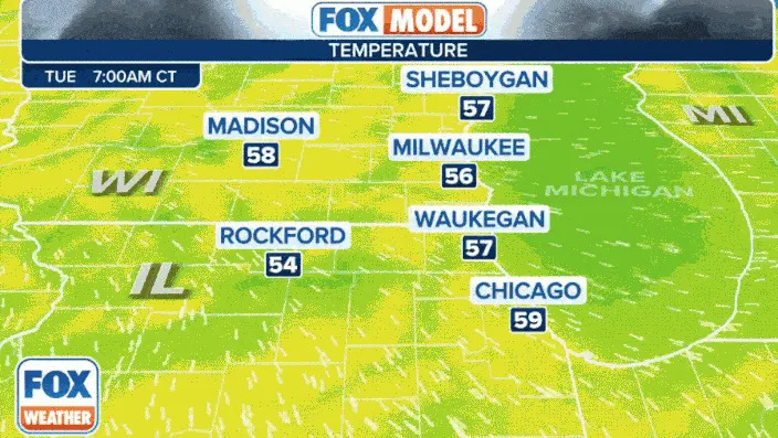
“Pneumonia Front” To Sweep Midwest
A stark drop in temperature is forecast Tuesday across the likes of Chicago and Milwaukee as a “pneumonia front” careens down Lake Michigan, driving that water-chilled air into swathes of eastern Illinois and Wisonsin.
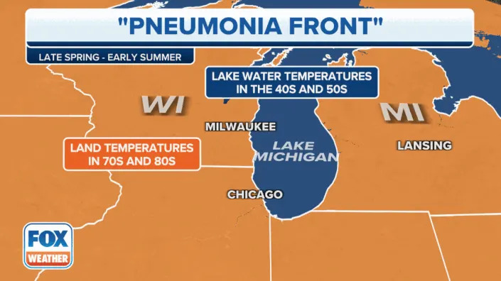
According toNWS meteorologists are expecting gusty NE winds to compound the already crashing temperatures:
A second, larger mass of frigid air is due to engulf much of the Eastern U.S. later in the week.
Temperature anomalies will be in the range of 4-12C below seasonal norms.

Astonishingly, a little Mid-May snow could also be in the offing, though only for the far northeast.
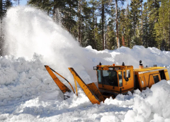
Due To Record Snow, Yosemite Park Roads Closed Until At least July
Snow continues to fall across the West’s higher elevations, following what was an all-time record-breaking season.
Tioga Road and Glacier Point Road in Yosemite National Park will remain closed for the foreseeable due to the snow.
Each spring, crews work to clear 45.5 miles of road between Crane Flat and Tioga Pass. As of a weekend update (May 13), plows have cleared just 11 miles so far and are barely approaching White Wolf, where the rooftops are only just starting to reemerge:

Despite plowing seven days a week, the road crew is making slow progress.
Roads remain buried under at least ten feet of snow, much of it heavily compacted, and crews will have to carefully navigate several hazardous avalanche zones.


There is not yet an estimated opening date for Tioga Road.
While authorities are hopeful Glacier Point Road will reopen sometime in July.
Delayed mountain openings is a story playing out across California this year:
And across Utah, too.
Here, snow crews have already exceeded the state’s $24 million snow removal budget by some 70%, according to Utah Department of Transportation spokesperson John Gleason.
Gleason said crews conducted snow removal services along 6+ million miles of state highways during the past season. This isn’t much of a surprise given the 900+ inches of record-smashing snow that settled on Alta between Oct 1, 2022, to May 1, 2023.
Utah lawmakers are now planning to increase the state’s snow removal budget by $20 million.
–Nothing says “catastrophic global warming” like a near-doubling of a state’s snow clearing budget.
Solar Filaments
Where flaring is concerned, unstable magnetic filaments pose a greater threat than sunspots, and they currently outnumber sunspot regions by roughly 3-1.
The below photo, taken May 15, shows at least 20 dark filaments scattered about the solar disk.

This means there are about three times more filaments than sunspot groups, with half-a-dozen directly facing Earth.
As explained by Dr Tony Philips of spaceweather.com, “solar filaments are twisted tubes of magnetism filled with dense plasma.”
These areas are famously unstable, continues Dr Philips, and “their eruptions can hurl massive CMEs into space. Sometimes the debris falls back to the surface of the sun, triggering a Hyder Flare — two explosions for the price of one.”
The severe geomagnetic storm of April 23-24 was caused by a filament eruption, not a sunspot — shown below:

Stay tuned for updates…


Given that the Russians believe the UK destroyed their pipeline UK citizens should be pretty upset they are freezing, can’t be a cheap spring for heat. https://www.reuters.com/world/europe/russia-says-british-navy-personnel-blew-up-nord-stream-gas-pipelines-2022-10-29/
Though a communist who once worked for the NYT blamed the US
I’d put money on the U.S. government blowing up the Nordstream pipeline. They’re corrupt assholes, which is why I don’t trust them to ever tell the truth.
And you are CORRECT!
Only America has a team capable of doing that exact job. Ask Biden and Victoria Nuland…they BOTH said it would be blown up…and it was.
Check this out: https://www.zerohedge.com/technology/nasas-new-ai-system-gives-30-minute-warning-cmes-strike-earth
P- monia front was monday or wednesday, today is going to be warm about 80F in madistan, wi. 70F yesterday and 70F wed, cannot speak for lake michigan cities which are always 5 to 10 degrees cooler than central and western cities caused by great lakes. Actually been a beautiful May here in Madistan. March and April were wet and cold and beyond 2 or 3 days those months were typical. May is when things transition to pleseant temps. Nothern Sconnie is always 2 weeks ahead and behind seasonal shits. It was strange yesterday, we had northeasterly winds but temp rise. Odd for sure. Keep it up Cap.
Good I hope that record smashing COLD hits the Midwest and Eastern US behind the front! We already have freeze warnings tonight for parts of New York and another deep upper level trough is expected to move southward from Ontario and Quebec later on, by about the 22nd. The cold air will discharge south into the NE and mid Atlantic region. I hope I freeze to pieces!
Suffering this much cold at the peak of a solar cycle is reason for great concern. Even without the predicted two decades of solar dormancy the temperature will spiral down as we head into the next natural minimum between solar cycles. The world is in for the shock of ten life times if the predicted two decade solar dormancy unfolds.
A huge snow mass on the ground absorbed
BTU’s when melting, so last winters huge snowpack will reduce the amount of warmth expected from solar radiation provided by the sun. Some of those sun rays are reflected back into space creating even more of a warmth deficit. Then there is those volcanoes 🌋. No help at all. What ever preparation you think you require get on with it. Time is short!
Add the number of Volcanos popping their tops adding dust up high and you get a real cold time in Wonderland!!!
Hello ! Newbie there
Can someone tell me what is the usual trend of the number of filaments and sunspots within a Solar cycle ?
Thanks
I think the nearly warm day arrived today in sunny Manchester…. We have had that orrible north wind for months, it felt like it may be changing direction . We will see
Yes. The weather has been miserable in the UK.
We’re all fed up and hoping for a bit of summer.
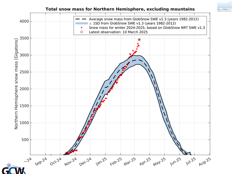
Re: Northern Hemisphere snow Extent
If one draws a trend line from 1988 to present across the LOW years
one gets the bottom of a right pointing triangle.
A trend line across the PEAK years from 2016 to present gives the top line
as a down trend CONVERGING pointing to the right.
This technical analysis of the converging bottoms and tops
Normally PRECEDES a BREAKOUT, either up or down, a very sharp steep rise or fall.
Knowing the fundamentals like we do, as Mystic’s Mystic
May 16, 2023 at 2:22 pm stated it is easy to predict the Breakout
WILL BE MASSIVE SNOW COVER INCREASE!!!
One can see such a Breakout from the years 1973-1975.
Then a steep fall occurs back to 41 Million.
One can bet after this Breakout the fall back will NOT go that low,
but perhaps back down this year’s level around 45 Million sq.km.
The graph doesn’t quite give an accurate picture as starting at
a low bottom scale of 40 sq. km the range is greatly magnified.
That means the effect of the snow cover itself is lost as the depth
of the snow is what is impacting the Western US the most, not the area!
It seems the amount of area covered will also be reflected in much much
greater depth in the central areas that normally get snow.
Dallas
Looks like the stassi are into you again – ads are blocked ☹️
Mr Schafernaker is ‘compromised’ having been previously fired by the BBC for acknowledging The Medieval Warm Period and The Little Ice Age…
This spotlight on UK cold, pneumonia, and solar filaments was interesting. What is the connection between them?
TheLawnfather Inc. is a reputed lawn care company providing high-quality mowing, cutting, & other lawn care services in Calgary, Alberta. Give us a call now
https://lawnfather.ca/residential-snow-removal
https://lawnfather.ca/commercial-snow-removal/
https://www.yarddawgslawncare.ca/
https://lawnfather.ca/