
Bicoastal Snowstorms Pummel U.S.; Feet Of Additional Snow Pound The European Alps; Moscow Drifts; + Polar Radio Blackout *Finally* Subsiding
Bicoastal Snowstorms Pummel U.S.
More than half a million Americans were without power at one point Wednesday, after bicoastal snowstorms prolonged the winter of 2022-23.
In California, some 40 of the state’s 58 counties have been put under a state of emergency as another atmospheric river hits; while switching coasts, over 4 feet of mid-March snow settled in parts of New York, New Hampshire and Massachusetts.
The nor’easter delivered mounds of snow, downed power lines and toppled trees — it closed hundreds of schools and businesses and put New York state and multiple counties in New Jersey under states of emergency.
California is experiencing its eleventh atmospheric river since December.
And looking ahead, “the extended range outlook from the Climate Prediction Center forecasts another atmospheric river arriving next week,” according to the National Weather Service, and backed up by latest GFS runs:

Heavy snow is sweeping Colorado, too. Feet are hitting the mountains, with disruptive flurries now reaching the Denver metro area, threatening to impact the Thursday morning and afternoon commutes.
A winter weather advisory went into effect starting at 3PM Wednesday for mountain communities, including in Rocky Mountain National park. Advisories are also in effect for Rabbit Ears Pass where the heaviest snow was seen Wednesday.
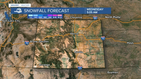
Windy and cold conditions will remain in Denver through the weekend, with further snow possible in Denver Sunday.
By the end of this event, well-over 2 feet of snow will have accumulated across Colorado’s higher elevations, including the Elkhead and Park Mountains, the Sawatch Mountains, and Colorado’s San Juans.
Not to miss out the Midwest, another powerful storm is expected to dump several inches of snow across the northern Plains and Upper Midwest to close out the week, adding to what is already the 8th snowiest winter in the Minneapolis area.

The temperatures will prove disruptive, and all, ranging from the low to mid-20s from Billings, Montana and Casper, Wyoming, through South Dakota. While farther north, the mercury will hold in the upper teens in Bismarck and Fargo, North Dakota.
The snowfall will increase in the Upper Midwest into Thursday, while the storm will be winding down for the likes of the Dakotas and Rockies. A swath of snow is expected to develop from central and northeastern Nebraska all the way through northwestern Iowa, Minnesota and northwestern Wisconsin on Thursday, with overnight flurries set to continue in eastern Minnesota, including Minneapolis and Duluth, as well as northern Wisconsin and Michigan‘s Upper Peninsula.
Winter weather alerts stretch from the Plains to the Upper Midwest, and run through the weekend for many.
Winter storm warnings stretch from northeastern Nebraska through southeastern South Dakota, northwestern Iowa, southwestern, central and northeastern Minnesota, northern Wisconsin and Michigan’s Upper Peninsula.
Northeastern Minnesota will see a foot of snow and blizzard conditions, with northern Wisconsin and the UP of Michigan seeing higher totals. Marquette, Michigan, for example, could pick up over 2 feet by the time the system exits over the weekend.

“It’ll be cold [too] — cold for March,” says Paige Marten, a NWS meteorologist — thanks Paige.
Feet Of Additional Snow Pound The European Alps
It’s snowing again in the Alps. The latest dumpings are arriving hot on the heels of the huge snowfalls in France as well as ski areas in Austria, Italy and Switzerland last weekend.
This week’s snow is proving more widespread than the weekend falls, reports inthesnow.com, with areas further east posting substantial accumulations even down to the valley floor.

Last weekend’s snowstorm brought 1.5 meters (5 feet) to ski areas in the northern French Alps.
Avoriaz, Cervinia, La Rosiere and Tignes were among the resorts posting the biggest jumps in their upper slope base depths (at 1m/3.3ft each). As a result, the avalanche danger has been increased to level 4 (of 5) on many slopes.
Moscow Drifts
“The closer to summer, the higher the snowdrifts” reports Russian weather website hmn.ru
Heat is in no hurry to settle in the capital region, continues the site, as thick clouds continue to deliver snow to Moscow’s streets.
This week has seen the city’s snow cover grow again, holding the snowpack higher than usual for the time of year. Last year, snow depth was 16 cm (6.3 inches) on March 14; this year, however, March 14 delivered a depth of 40 cm (15/7 inches).

Polar Radio Blackout *Finally* Subsiding
Following March 13’s “extremely rare” farside CME, shortwave radios inside the Arctic Circle are working again after a 3-day blackout.
The blackout is called a “polar cap absorption event” or PCA, explains Dr. Tony Phillips of spaceweather.com, caused by energetic protons accelerated toward Earth by the violent coronal mass ejection (CME).
Those protons are now ebbing, meaning normal propagation of shortwave radio signals can resume.

Minor CME Impact Sparks Northern And Southern Lights
Had Monday’s CME not been a farside event, had the discharge instead been Earth-directed, it would have caused untold disruption.
The electrical grid that our modern civilization has become utterly dependent on would be no more, at least on the sun-facing side of the planet, with it perhaps being years before the power could be reestablished, particularly in rural areas — that is, if society doesn’t completely fold in on itself during the ensuing blind Biblical-like panic.
Earth’s magnetic field is weakening, has been since the 1800s.
Coronal mass ejections striking our atmosphere are having a larger and larger impact.
Monday’s CME would have proved catastrophic if Earth-direct. This is shown by even minor ejections, such as that which struck our magnetosphere on March 15, sparking geomagnetic storms and also strong auroras over both ends of our planet.
That is, the North:

And the south:

Being days away from the March equinox, this is the time of year when Northern and Southern Lights can be seen at the same time. Nearly equal amounts of darkness allow sky watchers in both hemispheres equal opportunity to witness auroras, explains Dr. Phillips.
The CME that struck Earth on March 15 was caused by a magnetic filament erupting on the Sun (shown below) almost 4 days earlier. Though weak, its arrival sparked a series of alternating G1 and G2-class geomagnetic storms — a sign of the times.


Hi Cap,
I recently watched a video of Dr Patrick Moore, a co-founder of Greenpeace, who left when they changed their slogan to “humans are the problem”. He points out that carbon, particularly CO2 is the basis of life on Earth. Plants photosynthesise, combining CO2 and water into sugars that all animals and humans consume, thereby converting them back into CO2 and water, same as when we burn fossil fuels. A war against carbon is a war against life on Earth! Also I observed that it’s insane that the powers that wanna be are continuing a campaign of geoengineering, to block the Sun’s heat from reaching Earth, when we are already in a solar minimum. They claim that they plan to do it in the future but have obviously been doing it for decades. I have hundreds of timelapses from 2012-2013, showing the strange formations in the sky, trails causing raindrop nucleation etc. Do you think that the elites are aware of the cooling of the planet and actually plan to cool it even further, as another of their various attacks against humans? As I said, it is insane when we are faced with a small ice age that could last for several decades. Thanks for your work in showing the extremes of Earth’s climate and your other observations about the “crazies in charge”! Regards.
Cap, Where can we/me/you get info on the ACTUAL position of the Magnetic North Pole?
What Agency will haver that info?
And THANKS Bigly for everything you do on Electroverse Sir!
https://www.youtube.com/channel/UC5eyItTI4iIx0kVBcpyGpRw