U.S. Snow Cover At Record Levels
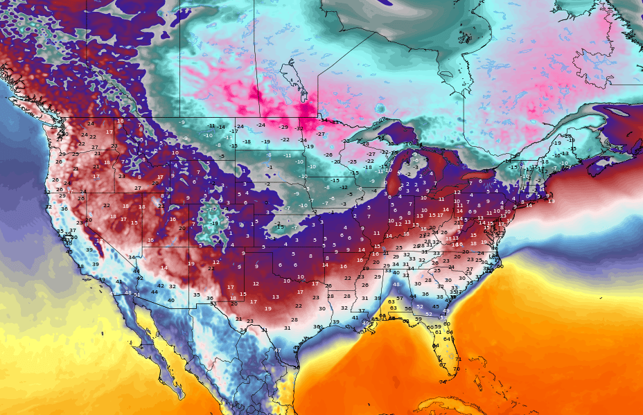
America’s first Arctic Blast of the season felled hundreds of low temperature records and resulted in the most extensive early-November snow cover in NOAA record books.
Heavy snow blanketed the Rocky Mountains, the northern Plains, the Great Lakes and northern New England, resulting in 17.9% of the Lower 48 being under a layer of snow as the calendar flipped to November — a new record in books dating back to 2003.
For reference, the multidecadal average over the Lower 48 on Nov 1 is 5.5%.

Many locales posted their snowiest Halloweens on record.
With 8.8 inches, Muskegon, MI not only logged its snowiest Halloween ever but also its snowiest October day as well as month. While Glasgow, MT, the 14 inches has gone down as the snowiest start to the season there.
A mass of descending polar cold made all the snow possible, cold which broke hundreds of low temperature records across the country from Texas to Maine and drove the average temperature across the Lower 48 to 31.1F — more than 10F below the norm.
Mount LeConte, TN and Mount Mitchell, NC –for example– endured their earliest single-digit lows ever.
And looking ahead, additional pockets of polar cold are forecast to descend…

…dropping additional inches of snow:

Total snow mass across the Northern Hemisphere as a whole is also riding well-above the historical average:
Historic November Cold Sweeps Argentina and Australia
A late-season cold spell has gripped swaths of South America, namely Argentina.
The country is enduring its coldest November temperatures in recorded history.
A host of benchmarks have fallen for both low min and low max.
Among the new low mins is Córdoba Airport’s 0.1C (32.2F)–which broke the record of 2C (35.6F) set Nov 4, 1992; Chamical’s 1.6C (34.9F)–which smashed the 4.5C (40.1F) set on Nov 9, 2010; and Mendova’s 2.8C (37F)–which bested 1992’s 3.2C (37.8F).
Among the new low maxes, we have Gualeguaychú’s 13.8C (56.8F)–which broke the old 1992 record; and also Paraná’s 13.5C (56.3F)–which pipped 1936’s record.
Many more fell but you get the picture.
The cold was fierce, as much as 24C below the norm, and also widespread, gripping the majority of Argentina:

And briefly re. Australia.
While the West has cooked the East has frozen.
New November record lows have fallen in New South Wales, including the -2.5C (27.5F) at Young and the -0.1 (31.8F) at Parkes.
Chilly October For Uruguay
South America’s early-November freeze is engulfing Uruguay, too, carrying on from what was an anomalously frigid October.
October 2023 there average between -0.5C and -1C below the multidecadal norm.
Iceland’s Seismic Swarm
It was a cold October in Iceland, too.
The temperature finished -0.6C below average, according to the Icelandic Met Office (IMO):

Furthermore, some 900 earthquakes were detected in just a 12-hour period around Sundhnjúkagígar, Þorbjörn and Eldvörp, reports vedur.is, as deformation data shows continuing uplift in the area due to magma accumulation northwest of Þorbjörn.
The IMO is monitoring the situation closely.

Stronger Than Forecast Solar Storm
Two Coronal Mass Ejections (CMEs) impacted Earth over the weekend — one on Nov 4, another Nov 5:


The pair sparked strong G3 geomagnetic storms — far stronger than the ‘G2’ forecast by both NASA and NOAA:
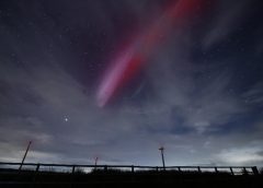
At the apex of the storm, bright auroras danced across the low-latitude skies of the U.S. and northern Europe.
Spectacular images have been posted to social media.
Texas (+33.6N) was hit in the U.S., with southern locales such as Poland and Ukraine hit in Europe:
Rare red aurora’s have been spotted as low as +40N in Crimea as well as along the Adriatic coast.
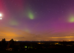
But not all of the lights were auroras.
“To our utter amazement we observed a striking phenomenon,” reports Martin McKenna of Swatragh, Northern Ireland.
“It was STEVE!”

“We were blown away by the intensity of the purple beam,” continues McKenna.”We could see it plainly with the naked eye, swelling and flickering in brilliance with delicate structures like those seen within a feather.”
STEVE is a recent discovery, explains Dr Tony Phillips of spaceweather.com: It looks like an aurora, but it is not. The soft purple glow is caused by hot (3000C) rivers of gas flowing through Earth’s magnetosphere at speeds exceeding 6 km/s (13,000 mph). These rivers are energized by strong geomagnetic storms like the one that happened over the weekend.
Wil Cheung observed an even more dramatic apparition of STEVE over Whitley Bay, England:

“It lasted for more than an hour,” marvels Cheung. “Strong auroras danced in the north while STEVE flowed through the sky to my south.”
Although our understanding of STEVE has rapidly progressed over the past few years, there are still many unsolved mysteries about the phenomenon, concludes Dr Phillips.
“Every sighting is about 75% enigma,” he writes, and as I have contended, is possibly an indication of Earth’s ever-waning magnetic field strength which continues to result in even minor solar ejections having a larger than expected effect.
For more, see “Another Weak CME Opens A Crack In Earth’s Atmosphere”:

Manic Monday Morning to Everyone!!!
SW Florida woke up to a Minus -9 F Sky temp.
Last year 2022 we did not have a minus temp until 17 December.
So this is 6 weeks early. Then I looked at it again, we had two minus
F degree Sky temp days in October 23!!!
The Chill is here!!!
With that news in last Friday was a news making day in my world also.
My First book was published at 77 years of age. Everyone should write
one long before that. Anyway it is collection of casino adventures I had
in the nineties while driving the Big Rigs cross country in the great USA!!!
Order your copy here:
https://www.lulu.com/shop/dallas-d-schneider/how-to-never-lose-money-in-las-vegas-pocket-book/paperback/product-p6dz9ng.html?page=1&pageSize=4
Thank you everyone!!!
Dallas
https://electroverse.info/wp-content/uploads/2023/11/UAH_LT_1979_thru_October_2023_v6_20x9-1024×461.jpg
https://www.accuweather.com/en/us/sarasota/34237/november-weather/328166
Dallas-
I was living in Las Vegas in the 90’s. You never know, you might have gassed up at the station I was working at.
I never lost money there, because I hate to gamble, but was one of the few who came out ahead, because I knew where all the great meal deals were. Sadly, the window on those has closed.
-Deb
Uh oh, all of those tremors in Iceland are right next to the Blue Lagoon hot springs. Those springs might be getting a lot hotter in the near future.
Measured time is a human construct with no basis in reality. Daylight savings time proved that once and for all.
Hurricane South of Greenland, another low pressure area NW US. Heat in the Atlantic rising North powering both cyclones the cold air heading South down NA behind the cold front. 100 F in Africa, -35 Greenland. The temp difference determines wind speed and barometric pressure.
https://www.windy.com/-Show—add-more-layers/overlays?temp,54.674,-22.676,3,i:pressure,m:fgfae5i
https://www.windy.com/-Show—add-more-layers/overlays?gust,46.073,-21.270,3,i:pressure,m:fe6aeXj
https://www.windy.com/-Show—add-more-layers/overlays?pressure,55.925,-37.266,4,i:pressure,m:fhnae2A
https://www.windy.com/-Show—add-more-layers/overlays?tcso2,54.162,-63.809,3,i:pressure,m:fhnae2A
https://www.windy.com/-Show—add-more-layers/overlays?snowAccu,next10d,54.059,-63.809,3,i:pressure,m:fhnae2A
Heat rising, cold sinking. Same as it ever was.